Tuesday, October 13, 2009

Mt. Washington - 10/10/09

Back in July(?) Jon E. got in touch with me looking to hit up a climb somewhere in the cascades. I told him I'd be stoked, but that my weekends were actually booked through October... So we went ahead and planned to hit up Mt. Washington (not the NH version) with the hopes of camping on the summit under the stars... Well, stupid us forgot that it snows in October and get's dark around 6:30, so that plan got scrapped. Anyway, we bailed the weekend before because it was snowing good and hard up in the mountains, which apparently doesn't make for ideal rock climbing conditions... But, favorable weather this past weekend let us squeek in one last climb before the sun leaves us for the next six months.

Aaron, Jon, Matt, and I left from the trailhead with varying degrees of optimism. The climb looked snowy, which I assumed would make it a "no go", but we figured we'd at least take a closer look since we drove up there. I had climbed the route 5 years before with Chris B, but that was under dry summer conditions and I had remembered that being pretty straightforward. As we got closer to the mountain, we found that many of the simple rock scrambles on the approach were covered in hard snow, and without thinking of bringing crampons these were a little more dicey than anticipated. Matt had his fill about 2/3rds of the way up the ridge and turned around to find a good spot to enjoy the view while we approached the summit pinnacle. Aaron volunteered for the first lead, which is the trickiest part of the climb... We waited and watched as he carefully inched his way out on a ramp and then up the face. The exposure here is absurd, and there isn't really any good chance to place protection as the rock is somewhat loose. As he topped out on the first pitch, Jon was weighing the option to continue to climb with us or bail and head down with his good buddy Matt (who was visiting from WV). Based on the timing of Aaron's lead and understanding of how much more climbing was ahead of us, he made the right decision to bail and go hang with his buddy (the decision to bail when you are so close and the conditions are good is one of the tuffest to make, so big ups to Jon for heading back - the mountain will be there next year).

I followed up the first tricky pitch with increasing respect for Aaron's lead... It was quite runout, with snow/ice on many of the holds and big air below my feet. It felt quite different than it had 5 years before during the summer, when I think we climbing w/o rope. I barely slowed down as I reached his belay, grabbing the rack, and leading up the last few hundred feet to the summit in one long pitch. The rock near the top is more solid so this simul-pitch went much quicker than anticipated. We hung out on top (views were incredible with the fresh snow) for a few minutes and then set off on the 4 raps to get back to solid ground. Overall a great day out with some good people. :)


Gotta love the water bottle point... "I think the mountain is over there..."


Three of the crew with the days spicy looking objective.


Crew on the approach ridge with Three Finger Jack and then Mt. Jefferson behind.


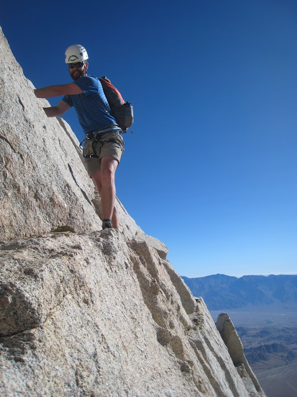
Some tricky and exposed downclimbing on the approach.


More tricky downclimbing.


Jon scrambling up right before the roped climbing begins (kinda scary here...)


Me getting ready to shread a huge summit air guitar


I'm not sure what was going on here, but I think Aaron my have been doing "the robot".


Peeking down the S. Face from the summit boulder.


"Way to ride that summit boulder Aaron..."


View of the Three Sisters from the top


Gotta have a group summit shot...


Aaron rigged and ready for the first of 4 dizzying rappels. Usually this part is a pretty straightforward downclimb, but w/ the snow we decided to rap.


More of the first rap...


Spontanious air guitar rappel technique Aaron was trying out.


Looking back once we were back on flatter ground.


Summit panorama, view down the S. Face, and Aaron on the final rappel, which was down the first pitch of climbing that he lead.


Parting shot.

Friday, September 11, 2009

Sierras with Mel, Amy, and Chris - 9/6/09

Lone Pine Peak – The Definition of “Too Much Driving”

In an effort to epitomize the name of this website, Melissa and I took off last Friday for a 7 hour drive down to Chris and Amy’s place in Susanville. There, after collecting two people and two dogs, we’d embark on an additional 7 hour drive down the Eastern Sierra to Whitney Portal for a couple nights of backcountry camping.

Side Story:
Along the way we stopped for what we thought would be a quick and painless breakfast, but what ensued ended up providing us with the running joke for the remainder of the trip. Shortly after our food arrived, Amy unsuspectingly loosened the cap on a jar of ketchup that had somehow developed massive internal pressure (either from heat or fermentation?) prompting the jar to literally explode like a grenade! I’ve never seen anything like it! Ketchup from the “bomb” literally covered everything within a 20 foot radius. The waiter, the people sitting at the adjacent table, the window behind us, the underside of the umbrella (luckily we were sitting outside and there was only one other table filled... had the bomb gone off inside, without exagerrating, I think dozens of people would have been hit!!!) and especially us. Literally, from the waist up, Mel, Amy, and I were completely covered in ketchup (Chris, by some strange mystery of science, had only a drop or two on his arm). For a moment we all paused digesting what had just happened… “Is this my blood all over my shirt, or is it ketchup? Hmmm… Tastes like ketchup…” As we began to realize what had happened, things began moving quickly. The waiter (who was wearing a white shirt now plastered w/ Ketchup) immediately began to stammer apologies, other waiters brought wet towels, Amy tried to explain what happen, Mel began to run her fingers through her now-ketchup-soaked-hair, and I just laughed and laughed. Long story short, we got a couple of meals for free, a good story, and ketchup stains that would last all weekend (I still had ketchup on my legs when I got home Monday night).

Anyway, okay, back to the real story and why we went to the Sierras… We had secured a backcountry permit for the Meysan Lakes area and had planned a weekend of backcountry camping (with a “little” climbing thrown in for Chirs and I). We didn't get to the trailhead until late, which put us in camp just as it was getting dark. We appeared to have this awesome area to ourselves, despite the busy weekend and absurd popularity of the nearby Whitney Portal area. Anyway, we got a great night of sleep but woke up early (w/ a headache... 11K feet elevation does that to me) so that Chris and I could take a shot at the North Ridge climbing route on Lone Pine Peak. The route itself is a granite spine gaurded by a number of towers that we'd either skirt around or climb directly over. After a bit of confusion over how to actually get onto the ridge, Chris and I made our way up scrambling terrain to the first tower on the ridge, after which most of our climbing was roped. We climbed all day long on the route, often along the ridge's knife-edge crest. Many times we'd climb up a few rope lengths, only to find a deep notch in the ridge that would require a ropelength of downclimbing. There wasn't much of a route description in the various guidebooks, which meant that most of our day was a "choose your own adventure". When the climbing appeared to become too difficult, we'd generally just find a way around on easier ground. Pretty neat. We brought small radios so we could keep in touch with the girls and wolf pack, who were spending the day hiking around the various lakes in the alpine basin a couple thousand feet below us.

Finally, just as it was getting dark, we finished the last pitch of climbing and stood on the summit. We played flashlight signal games with the girls thousands of feet below, and talked to them on the radio letting them know we were safely on top. Much to our dismay we realized that Chris had lost his hiking shoes far below us on the climbing route somewhere (while rummaging through his pack at one of the belay stations) leaving him with only his climbing shoes (think tight and uncomfortable). But, like a warrior going to battle, he re-laced his climbing shoes for the long descent back to camp. When we arrived 2 hours later, Mel and Amy had filtered water and made tea. Shortly after came a warm meal and cheesecake. It was more than I could have dreamed of after a long day of climbing, followed by a nightmarishly loose, dusty, and seemingly endless descent gully.

The next morning we packed up and hiked out the 4 miles (and 3000K elevation) without hearing a single complaint from Chris (who was still wearing his climbing shoes, but now with a heavy backpack). Beer, pizza, a bunch of caffene, and 14 hours of driving rounded out the 3 day weekend. Thanks again Chris and Amy for the good time, can't wait to see you guys soon!

Now for the pics:


The Crew!


Earlish start on Sunday, with setting moon and early morning sun on Mt. Irvine.


Nice reflection by our camp.


Holy granite batman! Do you like my granite camo shirt??


Chris on the scrambling approach


More scrambling, but getting closer now


Finally the ridge and climbing route unfolds before us!

Chris downclimbing into the first notch, where the roped climbing begins


Chris on the first roped pitch


Me following after the first pitch


My turn for a lead... The climbing here was spectacular, but unfortunatly the route dead-ended, and I was forced to downclimb about 100' and go a different way.


Chris following my roundabout traverse along the S. face of the ridge.


After rounding a corner we rappeled off of the first ridge tower into a notch at the base of the massive second ridge tower.


The description said go left, but we wen't right instead cause it looked better and were punished/rewarded with a hard pitch of climbing, for us, the crux of the day. Notice the camera leash in the frame, indicating that the pic was taken straight down! :)


Peekaboo! You can see the lakes basin behind me where Amy and Mel were playing.


Chris traversing along the knife-edge ridge crest. Quite exposed here!!!


Looking back at Chris' ridge crest belay.


My turn to lead along the sidewalk in the sky.


Finally we gained the base of the summit headwall. We traversed this catwalk and then unroped, hoping for an easy scramble to the summit. Instead we found 4 more pitches of easy 5th class climbing (still required a rope for safety) to the summit. No pictures of the last pitches as we were moving quickly to avoid nightfall on the route.


Chris traversing the easy but very exposed catwalk. In the background you can see our route, and right around the 16 second mark you get a view of Mt. Whitney, highest peak in the lower 48.


Parting reflection shot of Mt. Irvine.

Thursday, August 20, 2009

Eagle Creek - 8/16/09


My first effort to actually pull together a video... I hope you enjoy the music, it's a bit of a throwback. :)

Download the big version, it's way better!!!
http://dl.getdropbox.com/u/1794508/EagleCreekVid.wmv

____________________________________________________
Yesterday a small but solid crew (Mel, Aaron, Catherine, Matt, and I) descended Eagle Creek canyon in the Columbia River Gorge. This is something I’ve wanted to do for a long time, but each summer high flows or lack of a “crew” have kept Mel and I away.

The Eagle Creek trail is one of the most popular trails in the state and much of it is a narrow walkway hammered out of sheer cliffs that offers only occasional views of the amazing waterfalls, narrow gorges, and bottomless punchbowls below. On a summer weekend the trail sees hundreds of visitors, but rarely does anyone get a view of what the canyon looks like from the bottom up.

Our crew started the descent at Skoonichuck Falls, which was a nice warm-up 2 tier rap on greased rock into a really neat basalt punchbowl. Because of the force of the water, we didn’t do any of the rappels in the main watercourse.


Downstream from there we encountered our first swimming obstacle. A narrow slot pushed the water into what appeared to be a dangerous recirculation. While we debated if it was appropriate to swim through this, Matt tossed his pack in to see if it would flush cleanly through the hole. Nope, not really... As it spiraled around in the hole we realized that the only rescue throw rope was in the pack. Oops, learned that lesson the hard way! Eventually Matt’s pack flushed out and he chased after it (me with rap rope ready to toss in, just in case), only briefly getting dunked as he went through. While Matt set safety downstream everyone launched themselves and their packs and swam cleanly through.

Downstream from there was a few more jumps and then we entered the high bridge narrows. We floated through this 10’ wide x 600’ long hallway of rock and moss pretty much stunned by our surroundings. An audience on the bridge above gaped at our passage, probably wondering how we had got there and how we intended to get out.


Downstream there were more jumps and swims, as well as what seemed like a mile of slippery river rocks. I probably fell over a dozen times! That brought us to the top of punchbowl falls, allegedly the most photographed waterfall in Oregon. We rappelled this waterfall from a small tree on the left (free-hanging) directly into the bottomless punchbowl.


Once we were all down, we swam through the remainder of the punchbowl and downstream narrows into a world of tourists. Below punchbowl falls is the only creek level access people hiking in Eagle Creek really get, so there were a lot of folks there. As we approached, people gawked at us and took pictures. I’m sure we looked absurd wearing wetsuits and harnesses. Everyone wanted to talk to us. Aaron even heard someone say that we looked like we were from another planet (where we had come from seemed like another planet, so perhaps that was appropriate!)… We basically ran though the gauntlet of people (embarrassed by the attention), tossed our packs from the top of the next 20’ waterfall, and then jumped back into solitude.

Downstream from there we had a few more jumps (one was the highest we did on the trip, maybe 30 feet???). We knew that we were nearing the top of Metlako falls, so we approached cautiously, worried that the current would carry us over this 90’ drop. The water was slack enough that we were able to swim out about 10’ above where the flow pinched together and poured over the edge. The 100’ rappel into the punchbowl below was fully free-hanging as well, although this punchbowl had a very different character than the one above. Instead of sunny and blue with happy tourists gaping, this one seemed dark... It was deep enough that the sun wasn’t really hitting the bottom, which gave the water a black and angry look, and the force of the waterfall was creating it’s own waves and wind. Once down I pulled the rope and swam across the bowl towards the rest of the crew with my arms cramping up. Without a rope and wetsuit there is really no way to access this spectacularly beautiful place, so the knowledge that we were seeing something that only a few truly lucky individuals had seen added to the excitement. We floated on our backs through another hallway-type gorge. Downstream from there we had a few more jumps, and then finally exited the gorge 7 hours after we entered it that morning.


__________________________________________________
I’ve gotta say a huge thanks to everyone in our crew for rolling up, being solid, and making this trip such a good time. Like I mentioned, this is something I’ve wanted to do for years, but have just been waiting for the right conditions and the right people to do it with. On the list of amazing places I’ve been lucky enough to visit in my life, this one ranks pretty close to the top. :)